Mount St. Helens Fieldtrip
Sunday October 3, 2010
9:00AM - 5PM
Registration
October 3th, 2010 -
John Morris
(president of the
Institute for Creation Research)
is leading a 1-day educational field
trip of Mount St. Helens following
our
conference. Join us to learn how
this event helped us better
understand how catastrophic
processes work, leading to a better
comprehension of how the global
flood of Noah shaped the Earth's
rock record.
The field trip will involve a
seminar by John at the
Creation Museum of Mount St. Helens
and on-site teaching by John at the
Johnston Ridge Observatory. Willing
participants will then take an easy
2 mile hike.
Participant Obligations:
-
Participants
MUST
preregister for this event ($35 per person / $105 per
family).
-
Bring a sack-lunch. We will eat before leaving
Johnston Ridge.
-
Bring the cost of admission to the Johnston
Ridge Observatory ($8 Adult Pass / Free for ages 15 and under)
-
Transportation arrangements
will not be organized by the NWCN.
Tentative Trip Itinerary
- 9:00 AM Meet at Mount St. Helens Creation
Museum 4749 Spirit Lake Highway Silverlake, WA. 98645. (map
and directions)
- 9:15 AM John Morris seminar (Mount St.
Helens)
- 10:15 AM Drive to Johnston Ridge
Observatory (42 mi –
about 49 minutes)
- 11:15 AM Teaching by John and self-guided
tour of Johnston Ridge Observatory
- 12:00 LUNCH
- 1:00 PM Group hike (location TBD)
- ~3:30 PM Return
Meeting time and location?
9:00 AM
Mount St.
Helens Creation Museum
4749 Spirit Lake Highway
Silverlake, WA. 98645
Map and Directions
For more info: Call Chris Ashcraft
206-465-1635
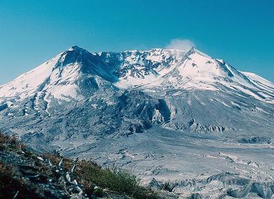
Background
 Mount
St. Helens is an active
volcano
in
Washington,
USA (the most active in the
Cascade Range). Its most recent series of eruptions began in
1980 when a large landslide and powerful explosive eruption created
a large crater, and ended 6 years later after more than a dozen
extrusions of lava built a dome in the crater. Larger, longer
lasting eruptions have occurred in the volcano's past and are likely
to occur in the future. Although the volcano seems to have returned
to a period of quiet, scientists closely monitor Mount St. Helens
for signs of renewed activity. Mount
St. Helens is an active
volcano
in
Washington,
USA (the most active in the
Cascade Range). Its most recent series of eruptions began in
1980 when a large landslide and powerful explosive eruption created
a large crater, and ended 6 years later after more than a dozen
extrusions of lava built a dome in the crater. Larger, longer
lasting eruptions have occurred in the volcano's past and are likely
to occur in the future. Although the volcano seems to have returned
to a period of quiet, scientists closely monitor Mount St. Helens
for signs of renewed activity.
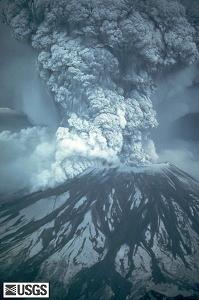
The eruption at Mt. St. Helens on
May 18, 1980 was an important geological event
because we observed and documented large-scale
catastrophic processes, which are extremely rare
occurrences. For
creation science, the event was most notable
because of the rapid deposition and erosion that
provided a sizable model of the type of activity
likely to have taken place during the great Biblical
global flood of Noah. The work done at the
volcano during its eruption by geologist,
Steven Austin, et. al. to document this event is
a highly recommended study.
Rapid deposition
Stratified layers up to 400 feet thick formed as
a result of landslides,
pyroclastic flows, mudflows, etc., during the
Mt. St. Helens eruption. Fine laminae from only a
millimeter thick to more than a meter high formed in
just a few seconds each. A deposit more than 25 feet
in thickness, and containing upwards of 100 thin
layers accumulated in just one day on June 12, 1980.
Naturalists have long claimed that stratified layer
such as those found in the geological column have
accumulated over vast periods of time, and that such
layers represent season variations. However, the Mt.
St. Helens deposits have demonstrated that
catastrophic processes are able to create these
geological formations in a short period of time.
Rapid erosion
Perhaps the most remarkable catastrophic events
to have occurred at Mt. St. Helens was the rapid
erosion that was accomplished by mudflows,
landslides, and waves of water. On March 19, 1982 a
small eruption melted the snow that had accumulated
in the crater over the winter, and a resulting hot
mud flow carved a system of canyons up to 140 feet
deep and 17 miles long in a single day. The deepest
of the canyons has affectionately been called the
little Grand Canyon of the Toutle River, and is
1/40th the size of its namesake. The small creek
that now flows through the bottom would appear to
have carved this canyon over a great length of time,
but this unique event has demonstrated that rapid
catastrophic processes were instead responsible. The
Grand Canyon in Arizona has also been claimed
for some time to have been carved gradually by the
Colorado River, but it is now becoming clear this
American icon is as well the result of catastrophic
erosion.
Read more at CreationWiki
Creation Mount St.
Helens Resources
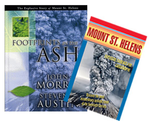
Purchase book
online
The eruption of Mount St. Helens helps us to understand many
processes that occurred during the Genesis Flood. These processes
include rapid erosion and deposition of stratified sediments,
including strata with fine laminations; the precursor sediments for
coal; rapid canyon formation; the origin of “fossil forests;” and
many others. Footprints in the Ask - contains abundant photographs
and is written for the layman.
• Discover how the
eruption of Mount St. Helens helps to explain Noah’s flood!
•
A fascinating pictorial review of the 1980 volcanic eruption that
shocked the world!
• Displays a visual outdoor laboratory with
geological lessons
• Provides observable evidence for a young earth
• An
encouraging teaching tool for biblical creationists
• Shows how God’s creation adapted to this natural disaster
through a recovered ecosystem
• Teaches proper insight on the
subject of death and suffering
In the aftermath of the Mount St. Helens eruption and the
subsequent glacier slide and mudflows, there remained a geologic
gold mine for earth scientists. No natural disasters in recent
history could compare with the variety of processes which resulted
from this tectonic and volcanic event.
As creation
scientists have carefully studied this geological phenomenon, they
have concluded that Mount St. Helens accomplished the same sort of
geologic work that biblical creationists attribute to Noah’s flood.
While this explosion was certainly much smaller in scale and
intensity, many lessons were learned through this occurrence that
help us understand the unobservable past.
Journey back to
this catastrophic event with scientists Dr. Steve Austin and Dr.
John Morris and see what was discovered as they reconstruct the
sequence of earthquakes, eruptions, avalanches, mudflows, and other
geologic processes and unveil their fascinating research findings!
Mt. St. Helens: Explosive Evidence for
Catastrophe
58 minute DVD
Purchase DVD
online
Geologist Steve Austin, Ph.D. shares the
exciting results of his explorations on Mount St. Helens and its
adjacent Spirit Lake. You will view spectacular and unique
photography of the volcano and its after-effects. Along with
thousands of other scientists and educated professionals, Dr. Austin
is convinced that the Biblical Flood is reliable and is vital to a
true understanding of history, its purpose, and destiny.
• Relive the 1980 eruption.
• Observe geologic structures
formed rapidly (strata, canyons, log deposits, etc.).
• Apply
what is seen to understand the origins of other geologic features
(Grand Canyon, Yellowstone, coal deposits, etc.).
• Contemplate
the significance of the volcano to our views of Earth, Noah's Flood,
man and God.
Purchase Book
and DVD Online
|