Geology: The Biblical View
| Student files |
Creation geology is based on the assumption that the Biblical flood described in the book of Genesis was a real and historical event of global magnitude, and is therefore also known as flood geology. Creation geologists seek primarily to show that Earth's geologic features are best interpreted within the scope of this Biblical cataclysm; including sedimentary strata, fossilization, fossil fuels, submarine canyons, plate tectonics, salt domes and frozen mammoths.
Flood geology is a historical science that is premised on catastrophism and the rejection of uniformitarianism. Creation geologists develop models based upon the historicity of the global flood, which are testable and falsifiable. Interestingly, the difference between flood models and the interpretations of naturalistic geologists is largely just one of intensity. All geologists today accept the view that allows for major catastrophes interspersed among large time periods of near stasis. In contrast, Creation model put a series of closely related cataclysmic events into a short period of time. Flood geologists explain strata with reference to catastrophes like the eruption of Mount St. Helens, which carved out enormous canyons and laid down large amounts of rock strata within the space of a single day.
 Creation
geologists reject radiometric
dating because
the idea of deep time (millions and billions of years) is required
for the dates of rock layers to be accepted as real. Since the flood
and the flood layers are known in creationism to be less than 5000
years old, computed old dates are completely irrelevant to any flood
model.
Processes[edit]
If the global flood actually occurred, then it would have had a radical effect on geology, and traces of that flood would be observable today, making flood models falsifiable.
80% of the Earth's crust is covered by sedimentary rock. There is an average of 1800m thickness of sediments on the continents of the Earth.[1] Sedimentary rocks are formed by deposition by water, wind or ice, precipitation from solution, and /or growth in position by organic processes (e.g., carbonate reefs). Layered rock strata are understood to have formed as suspended sediments settled out of moving water. Some flood geologists have proposed that a global flood is the most reasonable explanation for the means by which sedimentary layers came to cover so much of the continents.
Strata formation[edit]
Strata are visibly distinct variations of sediments deposited by moving water which form horizontally and vertically at the same time. Some of the features of strata which pose a severe problem for uniformitarianism are,
1. Fine and flat boundaries between a given strata and the one above and below it, which demonstrates 2 and 3:
2. An absence of erosion to any given strata. Strata are almost universally smooth at their boundaries. If any given strata were ever the surface of the earth for any extended span of time, it would show evidence of erosion, which is absent in virtually all strata.
3. An absence of gradation with the materials above and below. If strata formed over any extended span of time, each strata would blend into the one above it as different materials became available for deposition. The fine and flat boundaries of strata which are composed of different mixtures of materials shows that no gradation has taken place, and that each strata was quickly deposited upon the one below it.
4. Particle Size Distribution - Strata form by leading edge grain distribution[2][3]. Because larger particles in sediments settle before finer particles, the larger ones fall over the leading edge of the strata as it forms horizontally, and the finer particles remain in the solution longer, settling on top of the larger ones. This process results in strata having larger particles at the bottom and finer particles at the top. This feature is common to the vast majority of strata throughout the geologic column because most strata are comprised of more than one material, and not of grains of uniform size. Strata which are comprised predominantly of a single type of material with a very uniform particle size, such as clay, may not possess Particle Size Distribution which can be clearly observed, thought they still have fine and flat boundaries between themselves and the strata above and below them.
Because strata form in groups together at the same time, and because of the absence of erosion between them, there is no place for the uniformitarian to infuse deep time into the strata which cover the continents.
Rapid deposition by mudflow[edit]
Flood geologists believe that rock strata are best understood as being rapidly deposited during the Global flood. They document their position with observations made at catastrophic events such as the eruption of the Mt. St. Helens volcano. During the eruption of Mt. St. Helens, stratified layers up to 400 feet thick formed as a result of landslides, pyroclastic flows, mudflows, etc. Fine laminae from only a millimeter thick to more than a meter high formed in just a few seconds each. A deposit more than 25 feet in thickness, and containing upwards of 100 thin layers accumulated in just one day on June 12, 1980. Given the total inability of radiometric dating to date rock strata (see radiometric dating problems), documented instances such as Mt. St. Helens to support a catastrophic interpretation of rock strata, and the inability of uniformitarianism to explain fossilization (as discussed below), flood geologists have concluded that rock strata are best interpreted as having been laid down rapidly in a massive catastrophe such as the Global flood of Noah.
Liquefaction[edit]
Liquefaction, a phenomenon commonly seen in quicksand and earthquakes, is the process by which water pressing up from underneath sand or soil converts the sand into a suspension. Some flood geologists have argued that during a global flood, liquefaction would have occurred on a massive scale. They argue that in a global flood scenario, the tides would be unhindered by continents, creating enormous waves circling the globe. This, in concert with tsunamis from underwater earthquakes, volcano eruptions, and landslides, would cause wave loading: alternating periods of high and low downward pressure on subterranean water. The resulting periods of liquefaction and non-liquefaction would cause the sediments to layer into strata. Geological action while the sediments were still liquefied would cause the strata to bend smoothly in places, while earthquakes would cause radical discontinuities in others.
These flood geologists argue that massive liquefaction can explain phenomena such as transported blocks, sand plumes, coal and limestone deposits, the near total purity of the 500,000 sq. mile St. Peter Sandstone, smooth bending rock strata, and aquifers, and which remain inadequately explained by mainstream geology.[4]
In contrast, recent plume experiments by creationist geologists at Creation Evidence Museum at Glen Rose, Texas, have shown that moving water always creates sedimentary layering and liquefaction always destroys layering. Given the vast amount of sedimentary layers around the world, liquefaction is argued to have played a very minor part in the geologic record. (See the video below.)
Crossbedding
Sigmoidal shaped crossbed forms, commonly found in sandstone formations, are usually attributed to aeolian desert "sand dune" conditions. The high angle of the cross bedding is consistent with sub-aerial sand dunes. However, heavily loaded, high energy water currents flowing into ponded water also deposit high angle subaqueous sigmoidal cross beds. The size of the sigmoidal cross beds is determined by a combination of water depth and velocity.[5] The Coconino and Navajo sandstones from Nevada, Arizona, and New Mexico are consistent with formation beneath floodwaters.
Mountain building and deformed strata
A mountain is a mass of materials which has been uplifted from the lithosphere of the Earth. All mountains possess deformed strata. The Earth's mountains were produced by the process of Orogeny[6] which caused uplift. The horizontal movement of continental plates produced tremendous internal pressure and resistance against adjacent continental plates. This pressure has caused mountains to uplift at the Orogeny belt (edge of the plate) and also farther inland. A common feature of mountains is that they posses many deformed sedimentary strata which have concreted into solid rock.
The existence of folded and bent (deformed) strata, particularly those of mountains, discredits the uniformitatian explanation of mountain building because rock will not bend unless subjected to extreme confining (overburden) pressure and/or at high temperature.[7] Cold rock is brittle and will not bent, but will instead break.[8] Because mountains possess deformed strata, mountain building by uniformitarian process would require the materials to have been deep inside the Earth where the confining pressure (overburden pressure) in all directions could be great enough to prevent the material from fracturing and becoming pulverized. If the material were not deep in the Earth, there would be a lack of confining pressure above it, and it would move in the direction of the least confining pressure, which would be upwards towards the Earth's surface. Increasing temperature will increase ductility of rock, but temperatures great enough to significantly improve ductility (300-600C) are at depths of kilometers below the Earth's surface.[9]
In actuality, mountain building by uniformitarian process would require that the materials of which the mountain is comprised, including it's sedimentary strata, to have been pushed deep into the earth and subsequently covered with deep overburden which would be great enough to temporarily prevent uplift under great pressure. It's strata could then become deformed by heat and confining pressure. Once the strata had become deformed, the overburden would then have to be removed to allow uplift unless we are to expect the Earth's mountains to be as high above the Earth's surface as the depth of overburden necessary for deformation. At that time, the mountain could then become a feature of the Earth's surface by uplift. This scenario is so implausible as to be considered utterly absurd for a number of reasons, most obviously because the uplift necessary to position them at the surface of the Earth and above it would reduce the mountain to a pile of crushed rock. Also, there would be no continuity of strata between the mountain and the land which surrounds it unless vast areas of the surface of the Earth were also subjected to the same process which created the mountain. Stated simply, mountains built by uniformitarian process do not exist.
The obvious explanation for mountain formation with deformed strata is that pressure was applied to recently deposited, sedimentary strata mixed with solid rock which were still moist, soft, and plastic. This pressure forced the materials upward while horizontal movement caused their folding. After their formation, gravity drew the water downward and out of the materials to pool below the newly formed mountain. The removal of water allowed the materials to concrete into solid rock. The existence of folded strata, particularly those of mountains, provides astonishing evidence that the mountains of the earth and their folded strata were created by rapid continental movement during the Noaich Flood. This evidence discredits the uniformitarian idea that mountains are millions of years old and formed over a period of millions of years.
Canyon formation
Submarine canyons
As the continents divided and the flood subsided, the water would flow into the new low-lying areas, which would fill to become seas, leaving the sediments to dry out of their liquefied state. The runoff during this period predicts the creation of extensive submarine canyon extensions to rivers, as the level of the sea would be much lower during this time, so that the rivers would remain rivers far out into today's "seas." Such extensions are found in the Congo, Amazon, Ganges, and Hudson rivers. They extend for thousands of miles underwater, thousands of feet under the sea; they are as deep as the Grand Canyon in places, and although not well understood by the mainstream scientific community, they are generally understood to have developed when sea-levels were significantly lower than today. Flood geologists argue that such submarine canyon extensions were formed as the floodwaters receded from the continents.
Land canyons
Flood geologists also conclude that land canyons such as the Grand Canyon were most likely formed during catastrophic hot mud slides such as those observed during the eruption of Mt. St. Helens. One particular hot mud slide at Mt. St. Helens carved a canyon 140 ft. deep and 17 miles long in a single day. Only a thin creek remains at the bottom of the canyon today, which would likely be interpreted as having carved the canyon "over millions of years," if it were not known first-hand that the canyon was carved in a single day.
Loess formation
Loess is a geologic term that refers to deposits of silt (sediment with particles 2-64 microns in diameter) that have been laid down by wind action (aeolian activity to geologists). As Genesis records:
And God remembered Noah, and every living thing, and all the cattle that was with him in the ark: and God made a wind to pass over the earth, and the waters asswaged. Genesis 8:1 (KJV)
As the wind blew and the flood waters receded, the mountain tops would have been the first to be exposed. The hydrologically sorted sediments from the land areas first exposed would then be carried by the wind and deposited elsewhere. We would thus expect loess deposits to be associated with high altitudes as we find in the Loess Plateau, China.
The loess in China is not very far away from the Tibetan plateau[10], which is known as the 'roof of the world'. The Ordos Desert, the Loess Plateau's current source of sediments, is just north the Loess Plateau, however the Tibetan plateau could have been an earlier source of sediments. While the Loess Plateau is 300 m thick, the deposits consist of different types of material, and there is red clay underlying the upper layers of loess. While the upper layers (162.5 m[11]) do show evidence of being deposited by wind,[12] the underlying red clay does not show such a pattern, suggesting the possibility that the red clay may be flood deposits while the loess is post-flood, with most of it deposited during the early post-flood period by massive post-flood sand storms.
Fossilization
The flood provided an excellent environment for the required quick burial of fossils. Preservation of complete animal or plant remains requires quick burial by sediments. Dead animals or plants which are not buried quickly decompose or are eaten before they can become preserved. Fossils are often found buried in hundreds of feet of solid, unbroken rock strata. Flood geologists infer that those rock strata were laid down in a relatively quick period, burying the organisms before they had time to decompose.
Flood geologists point to the existence of large oil deposits as the result of the accumulation of large amounts of dead plant and animal matter during the flood which were subsequently compressed below the surface. They argue that there is no evidence of fossil fuels being formed today, or any clear mechanism for how it could occur without catastrophe. They argue that the flood provides the necessary catastrophe.
Fossil pattern mechanisms
A major aspect of flood geology is attempting to describe and explain the distribution of fossils throughout the rock strata. Because the uniformitarian model dismisses outright any fossils which conflict with their model,[13] no quantification of such fossils is possible. Creationists have proposed numerous mechanisms able to produce fossil patterns during flood conditions. See flood mechanics for further explanation of this.
Ecological zonation
Organisms living in the same habitat would tend to get buried in similar rock at similar depths. Those in the same area and habitat would tend to be found in the same rock, while those near by in a different habitat would tend to be found in different rock. Also organisms living on the bottom of a body of water would tend to be found lower than those living on hills on land, with shore dwellers being in the middle.
Hydrological sorting
The remains of animals, particularly invertebrates, would tend to sort like any other form in moving water. Buoyancy, size and shape would all be factors. Buoyancy is one factor that cannot be determined from fossils.
Hydrological sorting in flowing water results in stratification moving horizontally as seen above rather than vertically. A typical cross section of such deposits is the same as is seen in the strata seen in rocks.[14][15]
Differential Escape
More mobile and faster organisms would tend to seek higher ground.[14] This separates organisms based on motility and at least in part intelligence. This would tend to separate men from trilobites, amphibians, and dinosaurs.
Biogeographic zonation
Animals which lived in the same area would tend to be found together. Those from other parts of the world would not be found with them. For example if a global flood occurred today, one would not expect to find elephants and opossums buried together.
Tectonic activity
By itself tectonic activity would not affect fossil order. But it could have pushed some strata over others before the sediment hardened. There is evidence of this at the Ghadames Basin.
Puzzling fossils explained
Layered rock
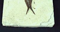
Standard concrete can provide a good model for how layered rock has formed, such as those of the Green River Formation. The picture at right shows a slab taken after a concrete spill occurred. Several layers of concrete formed as a result of the spill, which resemble the layers observed in slabs from Green River Formation.
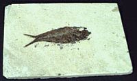
The image at left is a fossil fish in a slab from the Green River Formation, which has multiple visible layers. Such specimens are often found as polystrate fossils, passing through many layers. Furthermore this fish has been flattened indicating that it was exposed to significant pressure before it was fossilized. These conditions strongly argue in favor of catastrophic burial.
The same type of edge chipping can be seen in the slab as in the concrete. This strongly suggests that the Green River Formation resulted from liquefied material resembling concrete, such as massive mud slides. This may have been a post flood lake that had large mud slides dumped into it, rather than the annual deposits claimed by evolutionists. The mudslides could have been from the break up of other large post flood lakes.
Mud Cracks
This illustrates a mechanism for the formation of dessication cracks following liquefaction. It is also a clear example of how fossil subsurface "mud" cracks as it dries. The cracks formed in the lower layer without it being on the surface.
Fossil burrows
The first assumption is that fossil burrows are actually burrows rather than some other types of structures. This assertion is moot.
The other assumption is that fossil burrows are dwellings but there is evidence suggesting that they are attempted escape routes of buried organisms. If a burrowing organism is suddenly buried it won't accept death passively. It will try to dig its way out. Fossil burrows are consistent with this.[16]
Fossil footprints
There are at least five possible explanations for fossil animal tracks. It needs to be noted that none of these are mutually exclusive and none explain all fossil tracks, but together they seem to do a good job of explaining them all.
- Misinterpretations are features in rocks such as air bubbles, that happen to cause a track like pattern. These probably account for only a small portion of fossil tracks and then only those attributed to small animals.
- Post-flood disasters are cases where tracks are covered by sediment layers that were laid down by disasters that followed the flood.
- Post-flood tracks in soft flood sediment include cases in which the tracks were made post flood on exposed sediment, that had not yet hardened into rock. It could also occur in places where small pieces of rock came loose and were liquefied by rain or another source of water into a concrete type mixture, that hardened after an animal crossed it. This second type would be found separate from the main formation, but would be of the same type of rock.
- Small buried animal trapped in an air bubble is when an animal is caught in an air bubble and was able to move some before it died.
- Early flood tracks are footprints that were made while their habitats were being buried. Many animals would not have been killed instantly, but could have survived much of the early part of the flood. During the early stages tides and other fluctuations in water levels would expose portions of sediment. Animals would tend to seek exposed land. Those that made it to such places would leave tracks. In places where the water came and went several times, the same animal could have left several layers of tracks.
Some of the observations which support this hypothesis are:
- Dinosaur tracks[17] at Utah and Colorado are associated with coal mines, which suggest that the tracks were made while their forests were in the process of being buried.
- McKee and later researchers[18] discovered that the Coconino sandstone below the footprints of the Hermit Trail consisted of coarser grains, while finer grains were above these footprints. This is expected from hydrologic sorting.
- Gilmore (1927)[19] pointed out that of the hundreds of trackways that have been observed, almost all of them are going up the slopes of the cross bedded layers. This is expected from animals seeking higher ground.[20]
High-altitude marine sediments
Marine sediments[21] have been found on top of Mount Everest, implying that the flood covered the highest mountains, though this does not imply that Everest was at its current height at the beginning of the flood, if it existed at all.
References
- ↑ "[1]." Occurrence, Mineralogy, Textures, and Structures of Sedimentary Rocks, Stephen A. Nelson, Dept. Earth & Env. Sciences, Tulane University
- ↑ "[2]" Sedimentation Experiments: Is Extrapolation Appropriate? A Reply From the ’Drama in the Rocks’ Video Creator, Guy Berthault, April 1, 1997.
- ↑ OCN 201"[3]." Laboratory#6 – Sediment Particle Size Distribution and Turbidity Flows, Spring 2018, University of Hawaii.
- ↑ Brown, Walt. "Liquefaction: Testing the Theories." In: In the Beginning: Compelling Evidence for Creation and the Flood, on-line ed., 2008. Accessed October 17, 2008.
- ↑ Flood, P.G., 1985, "Origin of large-scale crossbeds in the late Permian coal measures of the Sydney and Bowen Basins, Eastern Australia", International Journal of Coal Geology, Vol. 5, pp 231-245
- ↑ Orogeny "[4]."Teaching Structural Geology in the 21st Century, SERC, Carelton College.
- ↑ Deformation of Rock "[5]."Stephen A. Nelson, Tulane University, 29 September 2015.
- ↑ Deformation of Rock "[6]."Stephen A. Nelson, Tulane University, 29 September 2015.
- ↑ Deformation of Rock "[7]."Stephen A. Nelson, Tulane University, 29 September 2015.
- ↑ Wittke JH. "Geography of the Tibetan Plateau." From "Tibet: a Virtual Field Trip," Northern Arizona University, March 27, 2006. Accessed October 17, 2008.
- ↑ Sun D, Shaw J, An Zhisneng, et al. "Magnetostratigraphy and paleoclimatic interpretation of a continuous 7.2Ma Late Cenozoic eolian sediments from the Chinese Loess Plateau." American Geophysics Union, 1997. Accessed October 17, 2008
- ↑ Tenenbaum D. "Loess is more." The Why Files, March 14, 2002. Accessed October 17, 2008.
- ↑ Woodmorappe J. "Anomalously Occurring Fossils". Creation Research Society Quarterly, Volume 18, March, 1982.
- ↑ 14.0 14.1 Segraves, Kelly L. "A New Set of Questions." In The Great Dinosaur Mistake, online ed. The Parent Company, 2003, p. 26. Accessed October 17, 2008.
- ↑ "The Cataclysm." Creation Resource Sheet, n.d. Accessed October 17, 2008.
- ↑ Woodmorappe, J., 2002. "Surface and Subsurface Errors in Anti-Creationist Geology." CRSQ 39(1): 55-57.
- ↑ Lockley MG and Jennings C. "Dinosaur Tracksites of Western Colorado and Eastern Utah: Late Cretaceous Coal Mine Tracks." Paleontology and Geology of the Dinosaur Triangle, Averett WR, ed. Museum of Western Colorado, 1987. Accessed October 17, 2008.
- ↑ Santucci VL. "Stratigraphic Distribution of Tetrapod and Invertebrate Ichnofossils in the Permian Coconino Sandstone of Grand Canyon National Park and Adjacent Areas, Northern Arizona." Abstracts with Programs, Seattle Annual Meeting, Geological Society of America, September 6, 2003, p. 498. Accessed October 17, 2008.
- ↑ Brand, L. R., 1978. "Footprints in the Grand Canyon." Origins 5(2): 64-82.
- ↑ Oard, M. J., 2003. In the Footsteps of Giants. Creation 25(2): 10-12.
- ↑ Fry C. "Everest Rock Map Published." BBC, May 23, 2003. Accessed October 17, 2008.
External links
Creationist
- Analysis of the Main Principles of Stratigraphy on the Basis of Experimental Data by Guy Berthault
- Assessing Creationist Stratigraphy with Evidence from the Gulf of Mexico by Carl R. Froede Jr., and John K. Reed, Creation Research Society Quarterly 36(2) September 1999.
- Flood Geology Links Northwest Creation Network
- Flood models: the need for an integrated approach by A.C. McIntosh, T. Edmondson & S. Taylor, Journal of Creation 14(1):52–59, April 2000.
- Geology and the Flood by Henry Morris, Acts & Facts Aug 1, 1973
- Geology and the Flood of Noah PowerPoint presentation by Chris Ashcraft
- Geology Sinks in the Mud by Creation-Evolution Headlines
- More Creationist Research Part I: Geological Research by Duane Gish, Creation Research Society Quarterly 25(4):161 March 1989
- Stratigraphic Evidence of the Flood by Stuart E. Nevins. A Symposium on Creation (Vol. III), pp. 32-65
Geology and the Biblical Flood
| Student files | Teacher files |

